Our Hike Among The Grizzlies
25 July - 1 August 2002
by Lynn E. Garn
"The interesting thing about this hike is that you won't be at the top of the food chain!" So it was that my colleague at work, Clare Walters, concluded his proposal that some of us who work together go for a hike in the Bob Marshall Wilderness in Montana with its host of wild animals including grizzly bears, black bears and mountain lions.
Five of us who work together had agreed to go on a group hike or some other outdoor or camping activity. Each of us was supposed to propose a trip and provide an estimate of the cost and related logistics that it entailed. Five different suggestions were presented. But we quickly settled on a hike across the Continental Divide in Montana's Bob Marshall Wilderness Area or "The Bob" as it is known.
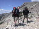
Thus evolved a one week, 60-mile backpacking trip for Bob Deaso, Jim Howe, Eddie Jacobs, Clare Walters and myself. Four of us had sons who wanted to go along. So Colin Deaso, my son Steven, Brian Howe and Paul Walters went along, making our group nine strong. The planning was significant. A route needed to be selected, food planned, equipment purchased, travel plans synchronized and physical conditioning started. In my case, I had to buy a lot of gear and do a lot of physical conditioning.
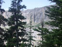
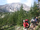
A view in The Bob
Click on image to enlarge
I'm sure some of the guys had never been in the woods for any length of time and away from modern conveniences or even an outdoor privy when nature called. Having grown up in northern Michigan, that wouldn't be totally new to me. But it would be a new experience for some making the hike. My daughter Barbara was most helpful in this regard. She bought me a book entitled, "How to Shit in the Woods," by Kathleen Meyer. It spent several paragraphs defending the title. But it was also interesting reading. My other son David bought me a copy of Bill Bryson's book, "A Walk in theWoods." After reading that, I had a healthy respect for black bears and the need for conditioning before setting foot in the woods.
Steven and I made several trips to our nearby REI store, buying hiking shoes, Smart Wool socks, shorts with zip-on legs to make them long pants, rain pants, polyester T-shirts, fleece shirts, breathable rain coats, backpacks, sleeping bags, tents, and a lot of other gear. The people at REI were always most helpful. And after they saw how much I was spending on each visit, they encouraged me to come back.
Since I wasn't the only one who wasn't in the best physical condition, we started taking short hikes with backpacks during lunch time at work. We started with about 25 pounds in our packs and gradually increased to around 50 pounds. But these lunch-time hikes were over relatively flat ground. So we decided we needed to take a few practice hikes in some real hills. Our work site is about 25 miles south of Washington, D.C. and all of us live in Fairfax, Woodbridge, Manassas, or Fredericksburg, in Virginia. The Shenandoah Mountains a little west of Washington, D.C., are the closest place that might give us some idea of what we could face in The Bob. So we hiked there several Saturdays to get in shape.
One of the first practice hikes we made in the Shenandoah Mountains was on a loop near a place called Big Schloss. The whole hike was about nine miles. We started at the base of the mountain and climbed in elevation for about 1500 feet in the first three miles of the hike. Then it was fairly flat for about four miles along the ridge of the mountain. Then we descended 1500 feet again, but this time in a distance of only two miles. So it was a lot steeper than the ascent. I hadn't expected that going downhill with a backpack would cause so much pain in my knees. Eddie was heard to remark, "That hike uphill was 'merely fatigue.' The hike back down was 'pure pain.'" It all reinforced the need for us to do a lot of conditioning before throwing ourselves at the mercy of The Bob.
Fortunately Clare Walters and his son Paul had hiked in The Bob before and volunteered to plan the meals. But we all still had to carry our own share of food and kitchen gear. All in all we each started the hike with about 45 pounds in our packs and ended with probably about 30 pounds.
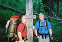
On 25 July 2002 Steven and I flew to Great Falls, Montana, where Clare picked up several of us for the trip to the trailhead. Clare and his son had flown out early to buy supplies. By the time we arrived at the trailhead about 80 miles west of Great Falls, it was a little after 5:00PM in the evening. Clare and Paul immediately divided up community supplies for each of us to carry. We quickly packed our backpacks and about twenty minutes after arriving at the trailhead, we hit the trail and headed up the mountain. The elevation at the trailhead was about 5800 feet.
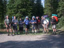
At the trailhead
Click on image to enlarge
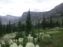
After hiking for about a mile, we started looking for a flat spot to camp. But there weren't any flat spots anywhere along the trail. Finally, after about a mile and a half of hiking up the trail, recognizing that we had to get our camp set up and food cooked before dark, we settled on a less than optimal camp site at about 6700 feet elevation. (Unfortunately I didn't get a GPS reading of the coordinates of the camp site.) None of us had a flat spot to pitch his tent. Although the camp site wasn't the best, we had a spectacular view. There was a beautiful waterfall on the mountain above our camp site.
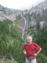
Me with waterfall in background.
Click on image to enlarge
At this site we began our daily ritual of pumping water through filters to rid it of harmful organisms, particularly giardia, a cyst that infects mammals, including humans, through drinking water. This illness is best characterized as a bad case of diarrhea with explosive flatulance. Its symptoms appear about seven to ten days after being infected. Fortunately we must have filtered our water well, or the water wasn't infected in the first place, because none of us caught it.
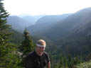
Steven with mountains in background.
Click on image to enlarge
I didn't sleep well that night. No one did. I kept sliding downhill into the side of my tent. And some time in the night a strong wind came up making me think we were in for a heavy rain storm. But the wind died down, we didn't get any rain, and I wiggled back uphill inside my sleeping bag for the "umpteenth" time and tried to go back to sleep. That was the only night I didn't sleep well. Every night after that I was tired and sore enough that I slept very well.
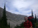
Me with mountains in background.
Click on image to enlarge
The morning of 26 July we had a breakfast of instant oatmeal or Cream of Wheat, instant coffee or hot chocolate, and instant juice. Other mornings on the trail the oatmeal or Cream of Wheat might be replaced with grits and powdered cheese. One morning we had "powdered" scrambled eggs, hash browns and bacon. Once the eggs were mixed with water, I couldn't tell the difference from scrambled eggs at home.
After breakfast, We packed our gear and started up the mountain again. That morning while hiking we saw seven mountain goats. At one point they were only about 30 yards away from us as we passed them on the trail. They didn't try to run away as we walked past. After a couple more of hours climbing, we were at Headquarters Creek Pass and the entrance to The Bob. It was about 7700 feet elevation.
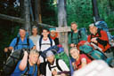
Click on image to enlarge.
The guys who work together at the entrance to The Bob.
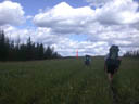
The remainder of that day, our first full day of hiking, was mostly along Headquarters Creek through an area that had burned over in 1988. There were lots of dead trees standing with no needles on them. So it wasn't difficult to see for some distance.
While hiking down the mountain side from Headquarters Creek Pass, we encountered a troup of Boy Scouts headed up the mountain towards the Pass. They were really dragging. And they still had a long way to go until they reached the Pass. They seemed to be carrying a lot of extra gear and in some cases the wrong choice of gear. One of them was carrying a heavy metal skillet. Fortunately we hadn't made that mistake.
Lunches on the trail were always something that didn't require us to fire up a stove. We had tortillas or crackers with hard salami and cheese or beef jerky. Or we had peanut butter and jelly, both from a tube, on pita bread. Also at lunch we always had some kind of dried fruit. Clare and Paul had dried a bunch of fruit in preparation for the trip. And it proved to be a great addition to the lunches.
Late that afternoon, we stopped for a break at a spot overlooking the North Fork of the Sun River near where Headquarters Creek empties into the North Fork. Soon after we stopped, a Park Ranger came up on horseback with two pack horses. He'd been following us and was trying to figure out how many were in our group from the unique tracks of our boots in the trail.
Part of his job is to know what's going on in the Wilderness. So he asked us where we planned to be each night we were in The Bob. Then he cautioned us about making sure we hung our food up at night in a "bear tree" at least 12 feet off the ground and at least four feet from the trunk of a tree because we would be in bear country with both grizzlies and black bears that would get into our food at night if we didn't hang it where they couldn't reach it. Clare and Paul had already been through all this in earlier trips to The Bob. But all of us still listened as if it were the first time we'd heard the caution. Shortly after he told us this, his horses suddenly got skittish whereupon the Ranger motioned to a spot about 100 yards away where a mother bear and her cub were crossing the path we'd just come over.
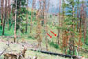
Picture with bear and cub in it.
Click on image to enlarge
It was as if the Ranger had choreographed the bears' appearance to emphasize his words of caution. The Ranger's horses had alerted him to the presence of the bears. The sow looked us over thoroughly from time to time as they slowly ambled ahead, remaining in our view for several minutes. Of course, none of us showed any fear. That might have been because the Ranger was there. Also, we had two canisters of bear spray that is supposed to ward off bears, but probably is only an expensive way of making hikers feel safe.
That night we camped at a spot along Gates Creek between Gates Park and the North Fork of the Sun River. (GPS coordinates - N 47° 47.054", W 112° 55.895") The next day, 27 July, we hiked toward Spotted Bear Pass, which is one place where a trail crosses the Continental Divide, one of the main attractions for going on the hike. Most of the day it rained, the only day we had any significant rainfall to contend with. At some point during our hike along the muddy trail, I asked Paul, a Lutheran Minister, if he remembered the movie "Patton" when the General called in the Chaplain and asked him to give a weather prayer. Paul was a bit more reluctant than Patton's Chaplain and didn't take the bait. Instead he replied, "You know it doesn't work that way." But after that day of rain, the weather was spectacular. Paul missed a great opportunity at the end of the hike when he didn't take credit for changing the weather.
Since most of our hike that day was through dense fir forest, the limited visibility caused by the clouds didn't affect our view. The fir trees would have prevented us from seeing any surrounding mountains anyway. We were glad it didn't rain on one of the days when we were in open territory and could see for miles.
Almost every one in our group had one day on the hike when he was dragging. Some might not admit it now that they've returned. But they couldn't hide it while on the trail. I think Paul and Colin managed to get through without a bad day. My tough day was actually near the end of our hike from Gates Park toward Spotted Bear Pass. Most of the day was trekking on fairly flat ground. But near the end of the day there was a gradual climb up the mountain toward the pass. It certainly wasn't as steep as the hike on the first full morning of hiking when we assulted Headquarters Creek Pass. But I guess I hadn't kept up on my snacks and energy foods during the day. So near the end it was sort of like when I "hit the wall" years ago when I ran a marathon. I was completely drained. As Clare remarked later, he had to pick me up off the trail that afternoon.
One thing that made it a tough climb was that it was also a bit longer than we'd planned. Looking at the map there should have been a flat area with good access to water near the trail well before the base of Spotted Bear Pass. But as we hiked along, we kept looking and looking for that flat spot with the stream nearby. Flat spots we encountered had no water anywhere in sight. So we'd press on or in my case drag on. Finally I pulled out the GPS and checked our location. We were well past the spot where the map indicated we should find water and a flat spot to camp. I think the message here is that some of these maps aren't as accurate as we'd been led to believe. Having concluded that we'd passed the last spot to get water before Spotted Bear Pass, we found the next fairly flat spot and started pitching our tents. While we pitched tents, Paul and Jim went back quite some distance with a couple of backpacks and all of the empty water bottles, pumped them full and lugged them back to the camp. I wouldn't have wanted to give back ground I'd already climbed to go back and find a camp near the last access to water.
Click on image to enlarge
On the trail on the day it rained.
Our camp site was about 300 feet elevation below Spotted Bear Pass and the Continental Divide. (I didn't get a GPS reading of this camp site either. I probably was too tired from the hike.) I set up my tent in an area with a lot of vegtation under some trees. That night I was awakened by a noise outside my tent. I suddenly realized that the bear tree selected for this camp site was just up the hill about 75 feet behind me. We were a good 12 miles or more from where we'd seen the mother bear and her cub. And I was pretty sure she hadn't followed us. Still, I wasn't sure what that noise was. Clare's comment that we wouldn't be at the top of the food chain while we were in The Bob was very high on the list of things going through my mind at that moment.
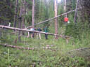
Hoisting the backpack with food up in the bear tree.
Click on image to enlarge
Also, the misstatements of some who referred to our trip as crossing the Great Divide weren't nearly as funny as they had been when I'd heard them back in the safety of an office or living room environment. But then as I listened carefully, it sounded more like hooves of some animal walking around. Soon I heard a noise like an animal chomping off vegitation and chewing. I forgot about the "food chain." Fortunately I didn't have to get up at just that moment to empty my bladder. I wasn't interested in startling an elk or even a small deer.
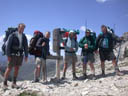
The Group at Spotted Bear Pass.
Click on image to enlarge
Steven and me at Spotted Bear Pass.
Click on image to enlarge
On the morning of 28 July we hiked up the trail to the Continental Divide at Spotted Bear
Pass, where we took our pictures and tested the theory that half the water
landing on the divide will flow east toward the Missouri River eventually
feeding the Gulf of Mexico and half will flow west toward the Columbia River
eventually feeding the Pacific Ocean. The elevation at the Pass was 6720
feet. Since it was a pass, the areas north and south of it were somewhat higher
elevation. But we weren't interested in setting any altitude records.
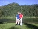
Steven and me at My Lake.
Click on image to enlarge
We didn't go on down the mountain toward the west on the other side of Spotted Bear Pass. Instead, we hiked south from the Pass, gradually climbing in elevation as we hiked toward My Lake, a
beautiful lake at about 7300 feet elevation in the mountains. There we took a
break before hiking on toward the Chinese Wall, presumably named because some
might think it resembles the Great Wall of China. The Chinese Wall is a natural
rock formation that is virtually a rock cliff about 1000 feet high that runs generally north and south
for about 32 miles.
The trail we were on linked up with the north end of the Chinese Wall. As we approached the wall, we saw a party of four hikers, a man and his wife and two grown daughters, hiking toward us. They had already hiked a good portion of the section of the Continental Divide trail that goes along the Chinese Wall, hiking from south to north. They planned to continue hiking north to somewhere in Canada. After comparing notes on where we planned to hike, we asked where they were from. They said they'd come from Arlington, Virginia, which is one of the Washington, D.C. suburbs and made them our neighbors! After we had parted company with them, one of the young men in our party dropped the news that he'd traded addresses with them. About a month after we arrived back home, he received a post card letting him know that they completed their hike safely.
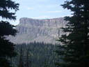
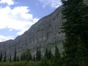
Pictures taken at the Chinese Wall - notice the tiny trees on the top rim of
the wall in the first and last pictures
Click on an image to enlarge
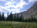
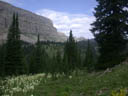
We hiked south along the base of the Chinese Wall, with the Wall on our
right and the view of the mountains we had come through on our left. For the
most part the hike along the Wall was through beautiful alpine meadows. We
hiked in these beautiful surroundings for about four or five miles until we
came to Moose Creek Trail, where we headed east, away from the Chinese Wall,
and back toward the North Fork of the Sun River. While hiking the Moose Creek
Trail we saw a large herd of elk about a mile away on a mountain on our left.
At some point along the hike after my afternoon of dragging myself up the trail toward Spotted Bear Pass, Paul asked me if I'd brought along anything that I wished I'd left behind. As I indicated earlier, I'd read Bryson's book, "A Walk in the Woods," with its description of his hiking partner discarding unneeded things in the early days of his hike. I think Paul was suspecting I'd brought along a lot of excess. But there really wasn't a lot of extra in that pack. I did bring fishing gear that proved to be flawed. I didn't catch a single fish with it. In retrospect I could have left it home since it didn't work. While on the trail, it was easy to rationalize that my failure to catch any fish was the fault of the gear and not the fisherman.
Celebrating crossing the Continental Divide
Left to right: Eddie Jacobs, Paul Walters, Brian Howe
Click on image to enlarge
That night we found a great camp site along Moose Creek. (GPS coordinates - N 47° 41.350", W 113° 5.831") After finishing dinner,
we all (except Brian) shared a swig of Jim Beam that Eddie had brought along to
celebrate crossing the Continental Divide. It was about at this point in the hike that Brian, the youngest hiker and one with a lot of Boy Scout experience, commented, "This is a lot more fun than Boy Scouts. There's no fighting over who does dishes."
Our camp site was in an an open spot that appeared to have been cleared by an avalanche from the mountain overlooking the area because there were a number of bent over trees and many dead trees pointing away from the mountain. That night at about 1:00AM Steven, who was in the next tent, heard a noise and also heard me stirring in my tent. So he hollered at me to tell me he'd heard a noise. I was pretty sure my snoring had waked him up. We soon were back asleep.
Normally we would wake up between 5:30 and 6:00 in the morning and usually head out immediately to a secluded spot to take care of our morning business. That morning, 29 July at about 5:30AM, we all were awakened by the noise of large branches breaking in some of the dead trees surrounding the camp site. Each of us assumed it was one of our group heading out to do his morning business. So we were all surprised when we gathered together for breakfast a bit later to learn that we'd all heard the crashing and breaking of branches and we'd all been in our tents when it happened. Our best specualtion is that an elk was headed down from the mountain for a drink at the creek when he got a whif of us and decided to make a hasty retreat.
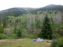
Moose Creek camp site - notice the laundry on the bushes on the right
Click on image to enlarge
That day we hiked along Moose Creek to the spot where it flows into the North Fork of the Sun River. During the hike we saw lots of evidence of animals including tracks from elk, bear, deer, and some that were probably a mountain lion. We also saw a lot of bear scat. This prompted Clare to observe that now we can answer the age-old question with great confidence and authority when someone asks us, "Does a bear shit in the woods?"
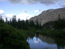
That evening we camped at perhaps our best camp site at the intersection of Moose Creek and the North Fork of the Sun River. (GPS coordinates - N 47° 43.414", W 112° 54.344") While camped there, several in our group caught a total of nine trout, providing a great supplement to our dinner that otherwise usually consisted mainly of dried vegetables and pastas because of their light weight.
In general dinners on the trail were something like mashed potatoes and beef stew, hearty Italian soup, chili and tortillas, or cous cous with mixed vegetables. One night we had tortellini carbonera, which was great. Other nights we had chili or Spanish rice. These meals were supplemented with cookies the first day and pudding every day after the first. For some reason or other I got picked to mix the pudding each night. I'd add the correct amount of properly filtered water and mix it up well. Then I'd add a small bag of dried cranberries or some other fruit that Clare and Paul had prepared. Of course, all of these dinners had little or no meat and were fishless except for the two days we caught fish.
There was always plenty of food. Each night as people finished eating there would still be food left. Colin and Paul would graciously ask if anyone wanted more and then, after a moment's hesitation when no one responded, would split the remainder between them. All in all, the meals were great. The absence of meat in our diet didn't hurt us in the least.
The following day, 30 July, we had to ford both the North Fork of the Sun River and Biggs Creek. To ford the North Fork of The Sun, we also had to ford Moose Creek.
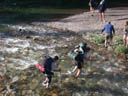
Fording Moose Creek.
Click on image to enlarge
All of us took off our hiking shoes and forded the river in camp shoes that we
didn't mind getting wet. The Sun River was deep enough to soak the bottom two
or so inches of our shorts. And it was swift and cold. Fortunately several of
us had trekking poles that were invaluable in maintaining balance in the swift
cold water. Biggs Creek was only about calf deep, just deep enough to make us
take off our hiking shoes and use our camp shoes when we forded it.
We hiked a few miles north along the east side of the North Fork of the Sun River to the spot near the pack bridge where the trail crosses the North Fork of the Sun River near Gates Park.
The hike from Moose Creek to the pack bridge.
Click on image to enlarge
During our hike that day we saw lots of deer and met up with the third or
fourth person on a horse with pack horses carrying supplies. He was another
Ranger. It was then that I began to think about the weight of the pack I'd been
carrying all week and to feel like one of the pack horses I spotted behind the
man on the horse. At that point I let everyone know that if I came back to The
Bob, I'd be riding a horse instead of being like one of the dumb mules
carrying all the weight.
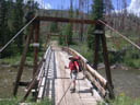
Click on image to enlarge. Me on the packbridge over the North Fork of the
Sun River near where Headquarters Creek empties into it.
We set up camp just north of the pack bridge, which is near where Headquarters
Creek empties into the North Fork of the Sun River and is also about 200 yards
from where we'd spotted the mother bear and cub four days earlier. (GPS coordinates - N 47° 46.969", W 112° 55.283") We had intentionally made this a short day of hiking so people would have plenty of time to fish. And once again we had great meal supplemented with lots of trout.
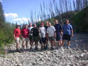
Click on image to enlarge. The group at the North Fork of the Sun
River.
The following morning around 5:00AM it started to rain lightly. I was afraid we would have a day of rain to hike in. But a half hour later the rain had stopped and didn't return all day. At 5:30AM I got out of my tent and looking around noticed that the backpack with our food supplies was not in the bear tree and the rope was dangling from the branch that we'd hung the pack over. Knowing that we were only about 200 yards from where we'd seen the mother bear and cub, I was sure that she'd found a way to outsmart us. I cautiously walked the 30 yards or so to the tree to examine the damages. But I didn't see any signs of a backpack and supplies being torn up. Then I looked around and saw the backpack under a tree. I later discovered that Paul had also heard the rain a half hour earlier and had retrieved the backpack to cover it and protect it from the rain. He figured the chances of the bear getting the supplies on the ground between 5:00AM and when we got up was worth the risk in return for keeping the supplies dry. His gamble paid off.
That day, 31 July, we started hiking at an elevation of about 5200 feet and
hiked up Headquarters Creek, toward Headquarters Creek Pass and its 7700 feet
elevation to exit The Bob and get back to the trailhead.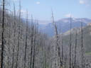
Click on image to enlarge.
That day was particularly windy and we were hiking back through the area that had
burned out in 1988. There were lots of dead trees all around and all of a
sudden we heard a loud crashing noise and looked up to see one of the dead trees falling over
about 30 feet ahead of us. It made a lot of noise. We're still debating whether
there would have been any noise if we hadn't been there to witness the tree
fall.
Late the afternoon we approached Headquarters Creek Pass.
Click on image to enlarge. Steven and me exiting The Bob.
It was quite windy and cold. But as we crossed over the Pass, we suddenly were
out of the wind and it was immediately warm. We descended about 300 feet in elevation to a
spring that fed a small pool of water. It was the pool of water that fed
the waterfall over our first camp site. Beside the pool was a flat spot where
we set up camp. (GPS coordinates - N 47° 49.591", W 112° 48.048")
Click on image to enlarge. Spring fed pool by our camp site.
There were several memorable things about that camp site. That afternoon after we'd set up our tents, two men approached on horseback with several pack horses, coming from the direction we'd come. They too were coming out of The Bob. As they approached, one of them hollered at us, "What day is it?" When I replied, "July 31st," he said, "No, what day of the week is it?" We were impressed that they had been away from civilization long enough to lose track of the date.
Another memorable thing about the campsite was the temperature of the water in the pool. This springfed pool was at the base of a cliff near which there was still unmelted snow - and this on the last day of July. The water in the pool was so cold that we could barely stand to wash our dirty dishes in it. Anyone leaving his hands in it for more than about 10 seconds found them becoming painfully numb.
Behind the camp site was a steep rock wall rising up to the mountain above. And a short distance in front of the site was a steep cliff going down the mountain. So there weren't a lot of trees around it. Unfortunately, some others using that site before we arrived didn't consider it important to leave the area as if no one had been there. There was evidence in the small wooded area that earlier campers or hikers had not brought along a trowel or didn't know how to use one. So if you happen onto this site using our GPS coordinates, please don't accuse us of failing to follow the "leave no trace" policy. It wasn't us!
Click on image to enlarge. A view of Headquarters Creek Pass through
the morning fog from our camp site east of the pass.
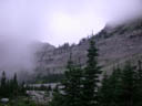
The following morning, 1 August, it was quite chilly, probably in the high 30's, and foggy
or cloudy. We could see only a small portion of the mountains towering over us
through the clouds that surrounded us. No one chose to wash up in the ice cold
pool.
As we had been hiking, all of us but one had gotten at least one blister on a toe, heel, or somewhere on at least one foot. Some of them were downright nasty and looked even worse. Each day after the first day there had been the morning ritual of medicating and patching up those blisters well enough for the day's hike. Sometimes we'd have to stop during the hike to replace dressings on blisters and cover them again in hopes they wouldn't hurt too much or make it difficult to hike. So by the end of the hike everyone but Colin had experienced a blister first hand and by this time we had quite an assortment of blisters. A day or two before the end of the hike someone had suggested that we get a picture of the blistered feet lined up to show that aspect of the hike. And we all had the best of intentions of doing just that the last morning. I'm not sure why we never took that picture. Perhaps we just forgot or perhaps the time needed to coordinate a bunch of shoeless people for a picture just didn't seem worth it. In any event, I know people put on boots and laced them up rather quickly that morning as if to say they were in a hurry to get back on the trail.
Click on image to enlarge. The trowel. You figure it out!
We hastily packed up and started down the trail. As I hiked, I thought of all the pictures I'd taken and the things I'd recorded in my journal. At that point I decided I'd write some of it down in a little story. I mentioned to Eddie that I thought "Our hike among the Grizzlies" would be a good title. He quickly replied, "You didn't see a single grizzly and you saw a whole lot of the trowel. So 'The Trail of the Trowel' would be a better title."
We quickly descended the rest of the trail to the trailhead and piled the nine of us in a van that definitely did not have adequate ventilation. But we all put up with each other for the 90 minute trip back to Great Falls rather than wait for someone to make a round trip with half of us and then return to pick up the rest of us.
We arrived in Great Falls about 11:30AM on 1 August, and immediately found a Godfathers Pizza restaurant, where we ordered the buffet for about $5.00, which entitled us to all we could eat. We actually didn't stuff ourselves because we'd agreed that in the evening we'd treat ourselves to the best steaks in town.
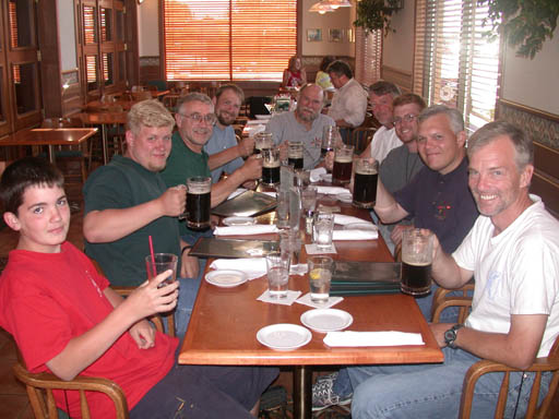
Click on image to enlarge.
So that night we all went to Jakers Restaurant and ordered big steaks and a pint or two of
beer to celebrate our trip. That meal was great! When I got home, I weighed
about eight to ten pounds less than when I started the hike because of all the
exercise, carrying the heavy backpack and hiking up and down mountains. I'm sure that
meal went a long way toward helping me gain back some of the the weight I lost on the hike.
The following day we flew home to the Washington, D.C. area. I'd taken a digital camera along and had taken about 240 pictures. So when we returned, we quickly burned some CDs of the pictures for the others. They had taken regular film cameras and had to wait for developing and printing of their pictures. So when they took a first look at my pictures, I caught a lot of teasing from some of the guys because of the disproportionate number of pictures of Steven and me among the shots taken with my camera. But I evened the score when they brought their pictures and I was able to point out the nepotism in their shot selection. Interestingly, the biggest culprit was the person who had complained the most about my shot selection! But the teasing was all in fun.
During our week in The Bob we'd hiked about 60 miles between elevations of about 5200 and 7800 feet. It was a great trip. Most of us would go back in a minute. And in my case, in spite of feeling like a "dumb mule" at one point on the hike, I'd go back even if I had to carry my own pack.
To contact me by mail, write:
Mr. Lynn E. Garn
12210 Redwood Ct.
Woodbridge, VA 22192-1611
Or email me at:
You are visitor number 6051 to visit this site.
Updated on 24 November 2002